Loch Gelly (Forth Basin) fishing map is included in Scotland - Fife Lochs nautical charts folio. It is available as part of iBoating : Inland Europe Marine & Fishing App (now supported on multiple platforms including Android, iPhone/iPad, MacBook, and Windows(tablet and phone)/PC based chartplotter. ).
With our Lake Maps App, you get all the great marine chart app features like fishing spots, along with Loch Gelly (Forth Basin) lake depth map. The fishing maps app include HD lake depth contours, along with advanced features found in Fish Finder / Gps Chart Plotter systems, turning your device into a Depth Finder. The Loch Gelly (Forth Basin) Navigation App provides advanced features of a Marine Chartplotter including adjusting water level offset and custom depth shading. Fishing spots and depth contours layers are available in most Lake maps. Lake navigation features include advanced instrumentation to gather wind speed direction, water temperature, water depth, and accurate GPS with AIS receivers(using NMEA over TCP/UDP). Autopilot support can be enabled during ‘Goto WayPoint’ and ‘Route Assistance’.
Have more questions about the Nautical Chart App? Ask us.
Fishing Info for Loch Gelly (Forth Basin)
Loch Gelly (Scottish Gaelic: Loch Gheallaidh) is a small loch in Fife, Scotland lying approximately 1.5 km to the south east of the town of Lochgelly which itself is named after the loch. The Gaelic name of the loch, Loch Gheallaidh, can be loosely translated as Loch of Shining Waters or Loch of Brightness. It is a broad, shallow flat bottomed basin approximately 1.75 km in length from west to east and 0.75 km wide at its maximum breadth. In May 1583 John Wemyss built a fort on the south side of the loch and kept an armed boat to prevent the Boswells of Balmuto fishing. Land around the loch is owned by Wemyss 1952 Trustees. The loch was surveyed on 11 May 1905 by Sir John Murray and later charted as part of The Bathymetrical Survey of Fresh-Water Lochs of Scotland 1897-1909.
More on Wikipedia...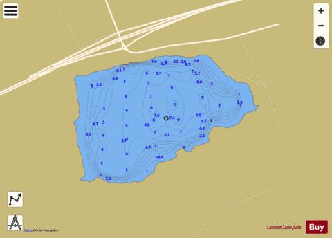
Loch Gelly (Forth Basin) Fishing Map Stats | |
| Title | Loch Gelly (Forth Basin) |
| Scale | 1:6000 |
| Area * | 143.45 acres |
| Shoreline * | 2.13 miles |
| Min Longitude | -3.29 |
| Min Latitude | 56.11 |
| Max Longitude | -3.28 |
| Max Latitude | 56.12 |
| Edition Label 1 | |
| Edition Label 2 | |
| Edition Label 3 | |
| Id | II_SCOT_74400554_3_scot |
| Country | Inland Europe |
| Projection | Mercator |
| * some Stats may include nearby/connecting waterbodies | |
| |||||||||||||||||||||||||||||||||||||||||||||||||||||||||||||||||||||||||||||||||||||||||||||||||||||||
|