Loch Trool (Cree Basin) fishing map is included in Scotland - Dumfries and Galloway Lochs nautical charts folio. It is available as part of iBoating : Inland Europe Marine & Fishing App (now supported on multiple platforms including Android, iPhone/iPad, MacBook, and Windows(tablet and phone)/PC based chartplotter. ).
With our Lake Maps App, you get all the great marine chart app features like fishing spots, along with Loch Trool (Cree Basin) lake depth map. The fishing maps app include HD lake depth contours, along with advanced features found in Fish Finder / Gps Chart Plotter systems, turning your device into a Depth Finder. The Loch Trool (Cree Basin) Navigation App provides advanced features of a Marine Chartplotter including adjusting water level offset and custom depth shading. Fishing spots and depth contours layers are available in most Lake maps. Lake navigation features include advanced instrumentation to gather wind speed direction, water temperature, water depth, and accurate GPS with AIS receivers(using NMEA over TCP/UDP). Autopilot support can be enabled during ‘Goto WayPoint’ and ‘Route Assistance’.
Have more questions about the Nautical Chart App? Ask us.
Fishing Info for Loch Trool (Cree Basin)
Loch Trool is a narrow, freshwater loch in Galloway, in the Southern Uplands in south-west Scotland. It lies in an elevated position in Glen Trool in the Galloway Forest Park and is approximately 8 miles (13 km) north of the town of Newton Stewart. The loch is the source of the Water of Trool which flows to the Water of Minnoch and the River Cree. There is a walking trail and footpath around the loch's perimeter. In April 1307 Robert the Bruce fought and won the Battle of Glen Trool on the shores of the loch. On its north side stands Bruce's Stone which commemorates the victory. Loch Trool is also reported to be the darkest place in the UK at night.
More on Wikipedia...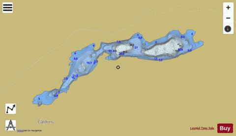
Loch Trool (Cree Basin) Fishing Map Stats | |
| Title | Loch Trool (Cree Basin) |
| Scale | 1:6000 |
| Area * | 139.29 acres |
| Shoreline * | 4.28 miles |
| Min Longitude | -4.51 |
| Min Latitude | 55.08 |
| Max Longitude | -4.47 |
| Max Latitude | 55.09 |
| Edition Label 1 | |
| Edition Label 2 | |
| Edition Label 3 | |
| Id | II_SCOT_74400512_0_scot |
| Country | Inland Europe |
| Projection | Mercator |
| * some Stats may include nearby/connecting waterbodies | |
| ||||||||||||||||||||||||||||||||||||||||||||||||||||||||||||||||||||||||||||||||||||||||||||||||||||||||
|