Carlingwark Loch fishing map is included in Scotland - Dumfries and Galloway Lochs nautical charts folio. It is available as part of iBoating : Inland Europe Marine & Fishing App (now supported on multiple platforms including Android, iPhone/iPad, MacBook, and Windows(tablet and phone)/PC based chartplotter. ).
With our Lake Maps App, you get all the great marine chart app features like fishing spots, along with Carlingwark Loch lake depth map. The fishing maps app include HD lake depth contours, along with advanced features found in Fish Finder / Gps Chart Plotter systems, turning your device into a Depth Finder. The Carlingwark Loch Navigation App provides advanced features of a Marine Chartplotter including adjusting water level offset and custom depth shading. Fishing spots and depth contours layers are available in most Lake maps. Lake navigation features include advanced instrumentation to gather wind speed direction, water temperature, water depth, and accurate GPS with AIS receivers(using NMEA over TCP/UDP). Autopilot support can be enabled during ‘Goto WayPoint’ and ‘Route Assistance’.
Have more questions about the Nautical Chart App? Ask us.
Fishing Info for Carlingwark Loch
Carlingwark Loch is a small freshwater loch in the historical county of Kirkcudbrightshire, Dumfries and Galloway, Scotland lying just south of Castle Douglas and is roughly rectangular in shape, trending nearly north and south. The name of the loch comes from the Scots Gaelic word Caer meaning fort and wark the old Scots language word for work. There are four artificial islets in the loch showing evidence of fortification and settlement, Ash Island is thought to be a crannog. Several archaeological finds have been retrieved from the loch including a bronze cauldron, sword and pan and two dugout canoes. Carlingwark Lane Canal is a 1.5 mile canal which opened between the loch and the River Dee, 1.5 miles away in 1765. It remained in use until its abandonment in about 1840, allowing flat-bottomed boats to transport shell-marl to farms along the route. There is a 5.25 km (3.26 mi) footpath around the loch and it is popular for bird watching and fishing. As of 5 March 2012 the loch and the land around it has been designated as a Site of Special Scientific Interest on account of its varied birdlife and grassland. In 1903 the loch was surveyed by E.R. Watson and later charted as part of The Bathymetrical Survey of Fresh-Water Lochs of Scotland 1897–1909. In 2009 an aerating fountain was installed at a cost of £10,000 to try to prevent the build-up of blue-green algae. The funding was provided by . The installation of the fountain was part of a wider development of by Dumfries and Galloway Council. However, further research showed that, owing to the relatively shallow depth of the loch, the fountain is ineffective and its use was discontinued. Barley straw, added twice a year, has been used very successfully up to 2019 to reduce the blue-green algae levels.
More on Wikipedia...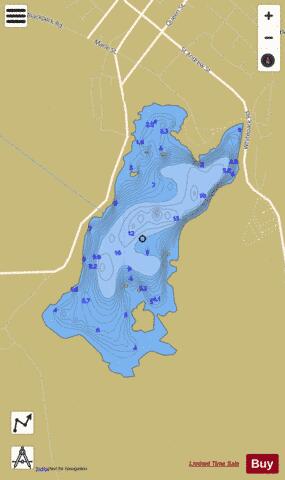
Carlingwark Loch Fishing Map Stats | |
| Title | Carlingwark Loch |
| Scale | 1:6000 |
| Area * | 94.77 acres |
| Shoreline * | 2.92 miles |
| Min Longitude | -3.94 |
| Min Latitude | 54.93 |
| Max Longitude | -3.93 |
| Max Latitude | 54.94 |
| Edition Label 1 | |
| Edition Label 2 | |
| Edition Label 3 | |
| Id | II_SCOT_74400508_6_scot |
| Country | Inland Europe |
| Projection | Mercator |
| * some Stats may include nearby/connecting waterbodies | |
| |||||||||||||||||||||||||||||||||||||||||||||||||||||||||||||||||||||||||||||||||||||||||||||||||||||||
|