Llangorse Lake fishing map is included in Wales - Powys Lakes nautical charts folio. It is available as part of iBoating : Inland Europe Marine & Fishing App (now supported on multiple platforms including Android, iPhone/iPad, MacBook, and Windows(tablet and phone)/PC based chartplotter. ).
With our Lake Maps App, you get all the great marine chart app features like fishing spots, along with Llangorse Lake depth map. The fishing maps app include HD lake depth contours, along with advanced features found in Fish Finder / Gps Chart Plotter systems, turning your device into a Depth Finder. The Llangorse Lake Navigation App provides advanced features of a Marine Chartplotter including adjusting water level offset and custom depth shading. Fishing spots and depth contours layers are available in most Lake maps. Lake navigation features include advanced instrumentation to gather wind speed direction, water temperature, water depth, and accurate GPS with AIS receivers(using NMEA over TCP/UDP). Autopilot support can be enabled during ‘Goto WayPoint’ and ‘Route Assistance’.
Have more questions about the Nautical Chart App? Ask us.
Fishing Info for Llangorse Lake
Llangorse Lake (Welsh: Llyn Syfaddon, variant: Llyn Syfaddan) is the largest natural lake in Mid and South Wales, and is situated in the Brecon Beacons National Park, near the town of Brecon and the village of Llangors. The lake is famous for its coarse fishing (particularly pike), watersports, the afanc (a monster nicknamed 'Gorsey') and has the only example of a crannog in Wales. Llangorse Lake is also one of the most mentioned sites in Welsh folklore. It is a site of international conservation importance. Due to the lake's long history of human activity, it has been known by several different names during its history, both in the Welsh language and in English: other names include the lake's original Welsh name, Llyn Syfaddon/Syfaddan, and Brycheiniog Mere. The name Llangorse Lake is comparatively recent.
More on Wikipedia...Popular fish species in this lake include Esox.
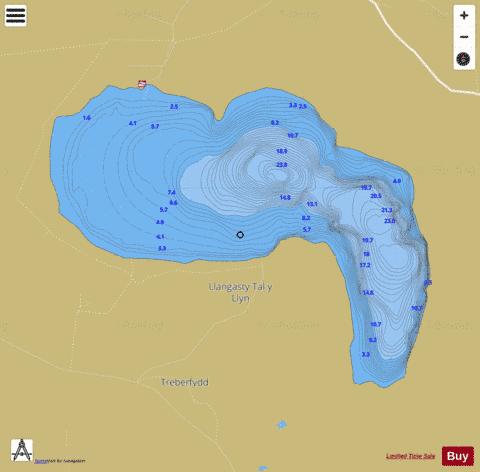
Llangorse Lake Fishing Map Stats | |
| Title | Llangorse Lake |
| Scale | 1:12000 |
| Area * | 345.19 acres |
| Shoreline * | 3.74 miles |
| Min Longitude | -3.28 |
| Min Latitude | 51.92 |
| Max Longitude | -3.25 |
| Max Latitude | 51.94 |
| Edition Label 1 | |
| Edition Label 2 | |
| Edition Label 3 | |
| Id | II_GB_llangorse_lake__gb |
| Country | Inland Europe |
| Projection | Mercator |
| * some Stats may include nearby/connecting waterbodies | |
| ||||||||||||||||||||||||||||||||||||||||||||||||||||||||||||||||||||||||||||||||||||||||||||||||||||||||
|