Lake Cwellyn fishing map is included in Wales - Gwynedd Lakes nautical charts folio. It is available as part of iBoating : Inland Europe Marine & Fishing App (now supported on multiple platforms including Android, iPhone/iPad, MacBook, and Windows(tablet and phone)/PC based chartplotter. ).
With our Lake Maps App, you get all the great marine chart app features like fishing spots, along with Lake Cwellyn depth map. The fishing maps app include HD lake depth contours, along with advanced features found in Fish Finder / Gps Chart Plotter systems, turning your device into a Depth Finder. The Lake Cwellyn Navigation App provides advanced features of a Marine Chartplotter including adjusting water level offset and custom depth shading. Fishing spots and depth contours layers are available in most Lake maps. Lake navigation features include advanced instrumentation to gather wind speed direction, water temperature, water depth, and accurate GPS with AIS receivers(using NMEA over TCP/UDP). Autopilot support can be enabled during ‘Goto WayPoint’ and ‘Route Assistance’.
Have more questions about the Nautical Chart App? Ask us.
Fishing Info for Lake Cwellyn
Llyn Cwellyn (Llyn Quellyn in some antiquated texts) is a reservoir in North Wales which supplies drinking water to parts of Gwynedd and Anglesey. It lies on the Afon Gwyrfai in Nant y Betws between Moel Eilio and Mynydd Mawr in the northern part of Snowdonia National Park. It has an area of 215 acres (0.87 km2), and is over 120 ft (37 m) deep. At the southern end is the small village of Rhyd Ddu. Although it is now dammed at the northern end, below the Castell Cidwm ridge, near the village of Betws Garmon this has not substantially increased the size of the natural glacial moraine lake that has existed since the last ice age. The lake is very deep and is one of the few lakes in Wales to support a natural population of Arctic char. The lake also is home to brown trout and there are otters that are regularly seen at the Castell Cidwm end. The lake has shared ownership between Lawrence Jones (businessman) owner of the Castell Cidwm estate at the Northern end and Welsh water, who own the right hand side that supplies the weir. The lake was originally owned by the Marquis of Anglesey who used the Castell Cidwm country house as his hunting lodge. The A4085 runs past the lake; however there are no lay-bys for picnics and the east side is now considered a Nature Reserve, and fishing is not permitted in the tree-lined area beside the road all the way down to Castell Cidwm. Fishing permits can be purchased for Cwellyn and fly fishing anglers can expect to catch wild brown trout here, which are abundant and often found along the shoreline which has easy wading. Char and salmon can also be caught, usually from the boats available for hire from the Cwellyn hotel. This lake is particularly dangerous when paddle boarding, wild swimming or kayaking in bad weather, as fast winds come down off Snowdon and through the valley, making it hard to travel back up the lake. This lake is a reservoir and electric engines only are permitted. Electric engines with 50lb thrust are quite adequate to get around the lake even in windy conditions. On the far side of the lake the land was planted as a commercial soft-wood forest and is now owned by Natural Resources Wales; however, logging has been stopped to prevent the water in the lake being polluted by silt generated by logging activities. In 2005 an outbreak of Cryptosporidiosis in the water supply drawn from the lake led to improvements being planned for the water treatment works. Work started in 2009 2 miles (3.2 km) down stream on an updated water treatment plant which included froth flotation, upward flow clarifiers and UV sterilisation of the treated water. The revised plant came online in September 2010 Further up the mountainside is the Welsh Highland Railway, which offers splendid views of the lake from the south. Road and railway both run from Caernarfon to Beddgelert and then through the Aberglaslyn Pass to Porthmadog. The railway comes from Caernarfon and as it approaches the lake veers left from the Castell Cidwm rock face through a hand carved rock cutting and under a small bridge before heading up the east side of the lake towards Snowdon Ranger railway station and later Rhyd Ddu railway station at the start of the Rhyd Ddu path to the summit of Snowdon. Rail and road run side by side for over half a mile to the summit of the mountain pass at Pitt's Head where the road passes over the railway before descending steeply through Nant Colwyn to Beddgelert. Pitt's Head is also the starting point of the 'Beddgelert' branch of the Rhyd Ddu path to Snowdon. Midway along the eastern shore of the lake is the starting point of the easier but less sensational Snowdon Ranger path to the summit of Snowdon. This route makes an excellent way down Snowdon as the view of the lake is magnificent whatever the weather. Since the Middle Ages the overland route from Caernarfon to Beddgelert via Llyn Cwellyn and then via the River Glaslyn and the Traeth Mawr to Cardigan Bay was often the preferred alternative to the long voyage round the Llŷn Peninsula.
More on Wikipedia...Popular fish species in this lake include Arctic char.
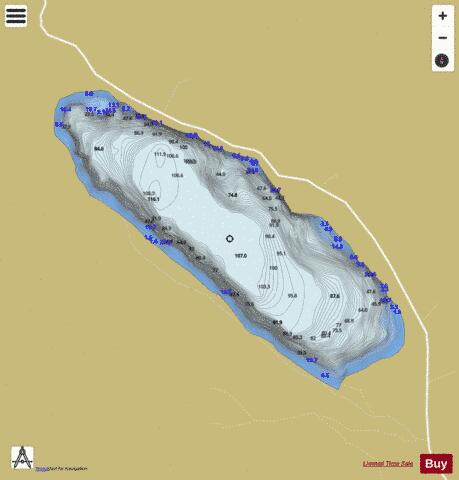
Lake Cwellyn Fishing Map Stats | |
| Title | Lake Cwellyn |
| Scale | 1:12000 |
| Area * | 222.68 acres |
| Shoreline * | 2.77 miles |
| Min Longitude | -4.16 |
| Min Latitude | 53.07 |
| Max Longitude | -4.14 |
| Max Latitude | 53.08 |
| Edition Label 1 | |
| Edition Label 2 | |
| Edition Label 3 | |
| Id | II_GB_eu_wl_gd_bg_cwellyn_2005_licc |
| Country | Inland Europe |
| Projection | Mercator |
| * some Stats may include nearby/connecting waterbodies | |
| |||||||||||||||||||||||||||||||||||||||||||||||||||||||||||||||||||||||||||||||||||||||||||||||||||||||
|