Bewl Water fishing map is included in England - East Sussex Lakes nautical charts folio. It is available as part of iBoating : Inland Europe Marine & Fishing App (now supported on multiple platforms including Android, iPhone/iPad, MacBook, and Windows(tablet and phone)/PC based chartplotter. ).
With our Lake Maps App, you get all the great marine chart app features like fishing spots, along with Bewl Water lake depth map. The fishing maps app include HD lake depth contours, along with advanced features found in Fish Finder / Gps Chart Plotter systems, turning your device into a Depth Finder. The Bewl Water Navigation App provides advanced features of a Marine Chartplotter including adjusting water level offset and custom depth shading. Fishing spots and depth contours layers are available in most Lake maps. Lake navigation features include advanced instrumentation to gather wind speed direction, water temperature, water depth, and accurate GPS with AIS receivers(using NMEA over TCP/UDP). Autopilot support can be enabled during ‘Goto WayPoint’ and ‘Route Assistance’.
Have more questions about the Nautical Chart App? Ask us.
Fishing Info for Bewl Water
Bewl Water is a reservoir in the valley of the River Bewl, straddling the boundary between Kent and East Sussex in England. It is about 2 miles (3.2 km) south of Lamberhurst, Kent. The reservoir was part of a project to increase supplies of water in the area. It supplies Southern Water’s customers in the Medway towns, Thanet and Hastings. Work began to construct the reservoir in 1973 by damming and then flooding a valley. It was completed in 1975 having been filled with over 31,300 million litres of water. The project cost £11 million to build. It is now the largest body of inland water in south east England. In winter, when the flow in the River Medway exceeds 275 million litres per day, river water is pumped to storage in the reservoir. There is an outline plan to raise the water level by a further 3m to increase the yield by up to 30% to help with the growing water demand in south-east England. This will however put further demands on the River Medway to supply the additional water required with the potential for environmental degradation in the river and the eco-systems that it supports. The reservoir in common with most large clean water lakes, is host to a large variety of wildlife.
More on Wikipedia...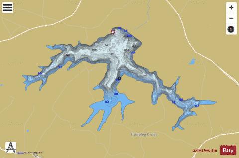
Bewl Water Fishing Map Stats | |
| Title | Bewl Water |
| Scale | 1:12000 |
| Area * | 762.83 acres |
| Shoreline * | 15.87 miles |
| Min Longitude | 0.36 |
| Min Latitude | 51.06 |
| Max Longitude | 0.43 |
| Max Latitude | 51.08 |
| Edition Label 1 | |
| Edition Label 2 | |
| Edition Label 3 | |
| Id | II_GB_bewl_water__gb |
| Country | Inland Europe |
| Projection | Mercator |
| * some Stats may include nearby/connecting waterbodies | |
| ||||||||||||||||||||||||||||||||||||||||||||||||||||||||||||||||||||||||||||||||||||||||||||||||||||||||||||||||||||||||||||||||||||||||||||||||||||||||||||||||||||||||||||||||||||||||||||||||||||
|