Lanker See fishing map is included in Germany - Schleswig-Holstein Lakes nautical charts folio. It is available as part of iBoating : Inland Europe Marine & Fishing App (now supported on multiple platforms including Android, iPhone/iPad, MacBook, and Windows(tablet and phone)/PC based chartplotter. ).
With our Lake Maps App, you get all the great marine chart app features like fishing spots, along with Lanker See lake depth map. The fishing maps app include HD lake depth contours, along with advanced features found in Fish Finder / Gps Chart Plotter systems, turning your device into a Depth Finder. The Lanker See Navigation App provides advanced features of a Marine Chartplotter including adjusting water level offset and custom depth shading. Fishing spots and depth contours layers are available in most Lake maps. Lake navigation features include advanced instrumentation to gather wind speed direction, water temperature, water depth, and accurate GPS with AIS receivers(using NMEA over TCP/UDP). Autopilot support can be enabled during ‘Goto WayPoint’ and ‘Route Assistance’.
Have more questions about the Nautical Chart App? Ask us.
Fishing Info for Lanker See
The Lanker See is a lake in the region of Holstein Switzerland in North Germany. It lies south of the town of Preetz in the district of Plön, and is crossed from south to north by the River Schwentine. The Lanker See has wealth of small bays.Almost the entire western area from the lakeshore to the tracks of the Preetz-Ascheberg railway line are a nature reserve. The Lanker See has a surface area of 323.6 hectares (1.249 sq mi), is up to 21 metres deep and is about 19 m above sea level (NN).It is divided into a large northern and a smaller southern part, that are joined by a passage a little more than 1 metre deep.Without the islands its shore length is 17 km.The Lanker See lies in the borough of Preetz and the municipalities of Kühren, Wahlstorf and Schellhorn. * v * t * e
More on Wikipedia...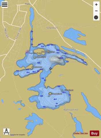
Lanker See Fishing Map Stats | |
| Title | Lanker See |
| Scale | 1:12000 |
| Area * | 870.26 acres |
| Shoreline * | 13.39 miles |
| Min Longitude | 10.27 |
| Min Latitude | 54.20 |
| Max Longitude | 10.32 |
| Max Latitude | 54.23 |
| Edition Label 1 | |
| Edition Label 2 | |
| Edition Label 3 | |
| Id | II_DE_lanker_see_de |
| Country | Inland Europe |
| Projection | Mercator |
| * some Stats may include nearby/connecting waterbodies | |
| |||||||||||||||||||||||||||||||||||||||||||||||||||||||||||||||||||||||||||||||||||||||||||||||||||||||
|