Tegernsee fishing map is included in Germany - Bavaria Lakes nautical charts folio. It is available as part of iBoating : Inland Europe Marine & Fishing App (now supported on multiple platforms including Android, iPhone/iPad, MacBook, and Windows(tablet and phone)/PC based chartplotter. ).
With our Lake Maps App, you get all the great marine chart app features like fishing spots, along with Tegernsee lake depth map. The fishing maps app include HD lake depth contours, along with advanced features found in Fish Finder / Gps Chart Plotter systems, turning your device into a Depth Finder. The Tegernsee Navigation App provides advanced features of a Marine Chartplotter including adjusting water level offset and custom depth shading. Fishing spots and depth contours layers are available in most Lake maps. Lake navigation features include advanced instrumentation to gather wind speed direction, water temperature, water depth, and accurate GPS with AIS receivers(using NMEA over TCP/UDP). Autopilot support can be enabled during ‘Goto WayPoint’ and ‘Route Assistance’.
Have more questions about the Nautical Chart App? Ask us.
Fishing Info for Tegernsee
The Tegernsee is a Zungenbecken lake in the Bavarian Alps in southern Germany. The lake is the centre of a popular recreation area 50 kilometres (31 mi) south-east of Munich. Resorts on the lake include the eponymous Tegernsee, as well as Bad Wiessee, Kreuth, Gmund, and Rottach-Egern. The lake is some 6.5 kilometres (4.0 mi) in length, with a width of 1.4 kilometres (0.87 mi) and an area of 8.934 square kilometres (3.449 sq mi). It reaches a maximum depth of 72.6 metres (238 ft), with an average depth of 36.3 metres (119 ft), and the normal water level is 725.5 metres (2,380 ft) above sea level. The lake flows into the River Mangfall, a tributary of the River Inn and thence the River Danube. The buildings of the former Benedictine monastery of Tegernsee Abbey lie on the banks of the lake. Now in private hands, they are now known as Schloss Tegernsee. The area around the lake is linked to Munich by rail through trains of the Bayerische Oberlandbahn, which, in the final part of their journey, travel over the tracks of the privately owned Tegernsee-Bahn. Pleasure boat services serve several points on the lake, and are operated by boats of the Bayerische Seenschifffahrt company. Adolf Hitler owned a house on the shores of Tegernsee and reclused here following the suicide of his niece, Geli Raubal, in 1931.
More on Wikipedia...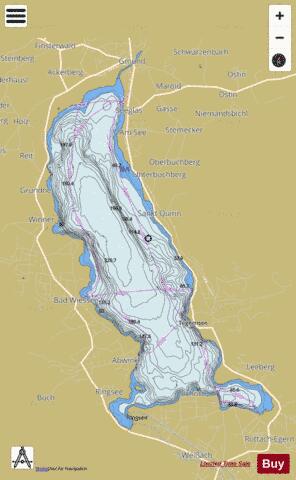
Tegernsee Fishing Map Stats | |
| Title | Tegernsee |
| Scale | 1:24000 |
| Area * | 2151.52 acres |
| Shoreline * | 14.53 miles |
| Min Longitude | 11.71 |
| Min Latitude | 47.69 |
| Max Longitude | 11.77 |
| Max Latitude | 47.75 |
| Edition Label 1 | |
| Edition Label 2 | |
| Edition Label 3 | |
| Id | II_DE_BY_tegernsee |
| Country | Inland Europe |
| Projection | Mercator |
| * some Stats may include nearby/connecting waterbodies | |
|