Kochelsee fishing map is included in Germany - Bavaria Lakes nautical charts folio. It is available as part of iBoating : Inland Europe Marine & Fishing App (now supported on multiple platforms including Android, iPhone/iPad, MacBook, and Windows(tablet and phone)/PC based chartplotter. ).
With our Lake Maps App, you get all the great marine chart app features like fishing spots, along with Kochelsee lake depth map. The fishing maps app include HD lake depth contours, along with advanced features found in Fish Finder / Gps Chart Plotter systems, turning your device into a Depth Finder. The Kochelsee Navigation App provides advanced features of a Marine Chartplotter including adjusting water level offset and custom depth shading. Fishing spots and depth contours layers are available in most Lake maps. Lake navigation features include advanced instrumentation to gather wind speed direction, water temperature, water depth, and accurate GPS with AIS receivers(using NMEA over TCP/UDP). Autopilot support can be enabled during ‘Goto WayPoint’ and ‘Route Assistance’.
Have more questions about the Nautical Chart App? Ask us.
Fishing Info for Kochelsee
Kochelsee or Lake Kochel is a lake 70 kilometres (43 mi) south of Munich on the edge of the Bavarian Alps. The western 1.7 km² or 28.3 percent of the lake lies within the borders of the town of Schlehdorf, while the rest belongs to Kochel am See. The southern edge of the lake lies up against the mountains and the northern shore is bordered by bog lands. The history of the settlement of Kochel (previously Quochcalun) begins with Birg bei Altjoch, a rock extrusion on the shore of the lake. The name Kochel is derived from the Latin cocula meaning head or cone. The Loisach flows into the lake at Schlehdorf and flows out at Kochel am See. A similar amount of water flows into the lake from the Isar through the Lake Walchen Power Plant.
More on Wikipedia...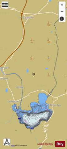
Kochelsee Fishing Map Stats | |
| Title | Kochelsee |
| Scale | 1:12000 |
| Area * | 1549.37 acres |
| Shoreline * | 28.44 miles |
| Min Longitude | 11.31 |
| Min Latitude | 47.63 |
| Max Longitude | 11.37 |
| Max Latitude | 47.73 |
| Edition Label 1 | |
| Edition Label 2 | |
| Edition Label 3 | |
| Id | II_DE_BY_kochelsee |
| Country | Inland Europe |
| Projection | Mercator |
| * some Stats may include nearby/connecting waterbodies | |
|