Lac La Loche fishing map is included in Saskatchewan Fishing Maps nautical charts folio. It is available as part of iBoating : Canada Marine & Fishing App (now supported on multiple platforms including Android, iPhone/iPad, MacBook, and Windows(tablet and phone)/PC based chartplotter. ).
With our Lake Maps App, you get all the great marine chart app features like fishing spots, along with Lac La Loche depth map. The fishing maps app include HD lake depth contours, along with advanced features found in Fish Finder / Gps Chart Plotter systems, turning your device into a Depth Finder. The Lac La Loche Navigation App provides advanced features of a Marine Chartplotter including adjusting water level offset and custom depth shading. Fishing spots and depth contours layers are available in most Lake maps. Lake navigation features include advanced instrumentation to gather wind speed direction, water temperature, water depth, and accurate GPS with AIS receivers(using NMEA over TCP/UDP). Autopilot support can be enabled during ‘Goto WayPoint’ and ‘Route Assistance’.
Now i-Boating supports Fishing Points in Lac La Loche.
Have more questions about the Nautical Chart App? Ask us.
Fishing Info for Lac La Loche
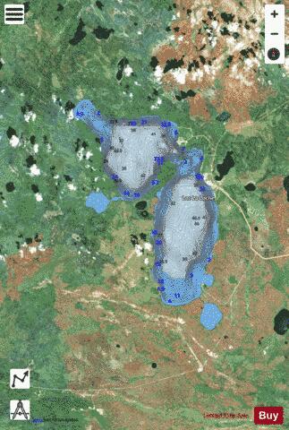
Lac La Loche is a lake in north west Saskatchewan near the Alberta border. The lake is part of the Churchill River system that flows into the Hudson Bay. The La Loche River at the southern end flows into Peter Pond Lake which is connected to Churchill Lake. Settlements on the lake include La Loche and Clearwater River (CRDN) on the eastern shore and Black Point on the southern shore. The estimated population of the three settlements in 2012 was 3500 people. The 19 kilometre Methye Portage or Portage La Loche at the northern end of the lake leads to the Clearwater River. The Portage a National Historic Site is also part of the Clearwater River Provincial Park.
More on Wikipedia...Popular fish species in this lake include Burbot, Cisco (fish), Lake trout, Lake whitefish, Longnose sucker, Northern pike, Sauger, Walleye, White sucker and Yellow perch.
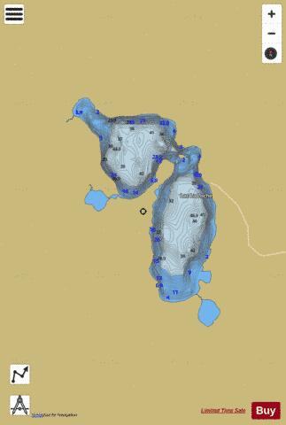
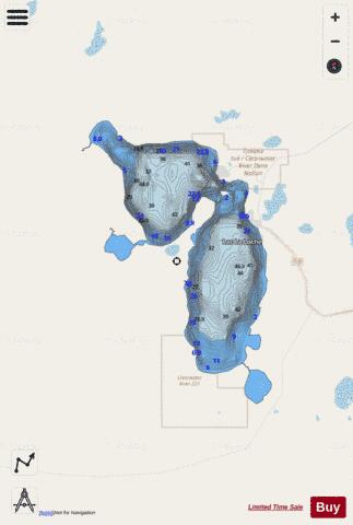
Lac La Loche Fishing Map Stats | |
| Title | Lac La Loche |
| Scale | 1:24000 |
| Area * | 53434.01 acres |
| Shoreline * | 80.60 miles |
| Min Longitude | -109.72 |
| Min Latitude | 56.32 |
| Max Longitude | -109.41 |
| Max Latitude | 56.58 |
| Edition Label 1 | |
| Edition Label 2 | |
| Edition Label 3 | |
| Id | CA_SK_Lac_La_Loche_sk |
| Country | CA |
| Projection | Mercator |
| * some Stats may include nearby/connecting waterbodies | |
|