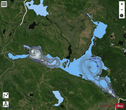
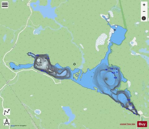
Fronsac, Lac fishing map is included in Quebec to Anticosti Island West nautical charts folio. It is available as part of iBoating : Canada Marine & Fishing App (now supported on multiple platforms including Android, iPhone/iPad, MacBook, and Windows(tablet and phone)/PC based chartplotter. ).
With our Lake Maps App, you get all the great marine chart app features like fishing spots, along with Fronsac, Lac depth map. The fishing maps app include HD lake depth contours, along with advanced features found in Fish Finder / Gps Chart Plotter systems, turning your device into a Depth Finder. The Fronsac, Lac Navigation App provides advanced features of a Marine Chartplotter including adjusting water level offset and custom depth shading. Fishing spots and depth contours layers are available in most Lake maps. Lake navigation features include advanced instrumentation to gather wind speed direction, water temperature, water depth, and accurate GPS with AIS receivers(using NMEA over TCP/UDP). Autopilot support can be enabled during ‘Goto WayPoint’ and ‘Route Assistance’.
Now i-Boating supports Fishing Points in Fronsac, Lac.
Have more questions about the Nautical Chart App? Ask us.
Fishing Info for Fronsac, Lac
The Fronsac Lake (French: Lac Fronsac) is a freshwater body located in the unorganized territory of Lac-Pikauba, in the Charlevoix Regional County Municipality, in the administrative region of Capitale-Nationale, in the province of Quebec, in Canada. This body of water is located in the Laurentides Wildlife Reserve. Lake Fronsac is one of the head water bodies of the Malbaie River. This mountain lake is entirely located in an area where forestry has always been the predominant economic activity. In the middle of the 19th century, recreational tourism activities took off. Due to the altitude, this lake is normally frozen from the end of October to the end of April; however, the safe ice circulation period is usually from early December to April. Secondary forest roads serve the southern part of the hydrographic side of Lake Fronsac. Another motorable road serves the northern part. The northeast part has no road.
More on Wikipedia...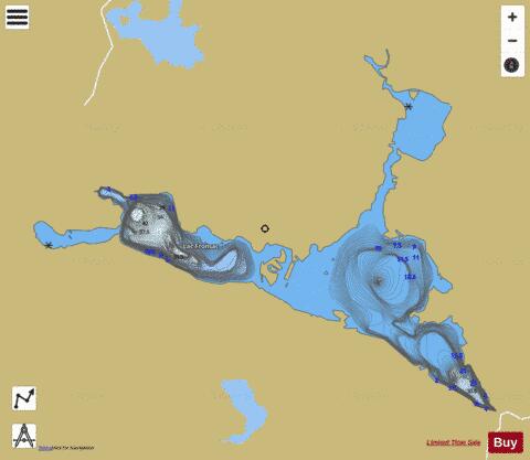
Fronsac, Lac Fishing Map Stats | |
| Title | Fronsac, Lac |
| Scale | 1:12000 |
| Districts | Charlevoix |
| Nearby Cities | Baie-Saint-Paul, Beaupré, Château-Richer, Sainte-Brigitte-de-Laval, Stoneham, Port-Alfred-Bagotville, Saint-Michel-de-Bellechasse, Cap-Saint-Ignace, Montmagny, Beaumont |
| Area * | 1098.92 acres |
| Shoreline * | 20.22 miles |
| Min Longitude | -71.06 |
| Min Latitude | 47.61 |
| Max Longitude | -70.99 |
| Max Latitude | 47.65 |
| Edition Label 1 | |
| Edition Label 2 | |
| Edition Label 3 | |
| Id | CA_QC_V_07784 |
| Country | CA |
| Projection | Mercator |
| * some Stats may include nearby/connecting waterbodies | |
| |||||||||||||||||||||||||||||||||||||||||||||||||||||||||||||||||||||||||||||||||||||||||||||||||||||||
|