Brome, Lac fishing map is included in Quebec to Anticosti Island West nautical charts folio. It is available as part of iBoating : Canada Marine & Fishing App (now supported on multiple platforms including Android, iPhone/iPad, MacBook, and Windows(tablet and phone)/PC based chartplotter. ).
With our Lake Maps App, you get all the great marine chart app features like fishing spots, along with Brome, Lac depth map. The fishing maps app include HD lake depth contours, along with advanced features found in Fish Finder / Gps Chart Plotter systems, turning your device into a Depth Finder. The Brome, Lac Navigation App provides advanced features of a Marine Chartplotter including adjusting water level offset and custom depth shading. Fishing spots and depth contours layers are available in most Lake maps. Lake navigation features include advanced instrumentation to gather wind speed direction, water temperature, water depth, and accurate GPS with AIS receivers(using NMEA over TCP/UDP). Autopilot support can be enabled during ‘Goto WayPoint’ and ‘Route Assistance’.
Now i-Boating supports Fishing Points in Brome, Lac.
Have more questions about the Nautical Chart App? Ask us.
Fishing Info for Brome, Lac
Brome Lake (French: Lac Brome) is a freshwater lake in the town of Brome Lake, in the Brome-Missisquoi regional county municipality of the Montérégie region of Quebec, Canada. It is the source of the Yamaska River. The name Brome Lake comes from Brome Township which itself was first recorded on the map of Gale and Duberger in 1795. The name of the township was shortly afterward transferred to the lake. The lake was first referred to under that name in 1815 by Joseph Bouchette, after which the name was kept. As for the name Brome, it probably is borrowed from the name of a village in Suffolk or Brome Hall, the castle of the aristocratic Cornwallis family, of which one of its members, Charles Cornwallis was titled Viscount Brome between 1753 and 1762. The Quilliams-Durrull Nature Reserve is on Quilliams Brook, a small stream that feeds into the lake.
More on Wikipedia...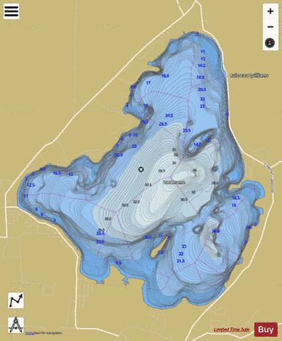
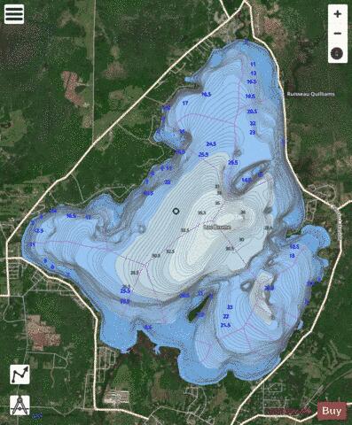
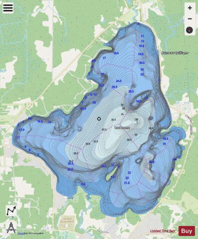
Brome, Lac Fishing Map Stats | |
| Title | Brome, Lac |
| Scale | 1:24000 |
| Districts | Brome-Missisquoi |
| Nearby Cities | Waterloo, Bromont, Val-Maher, Cowansville, Roxton Pond, Granby, Valcourt, Roxton Falls, LeBlanc, Magog |
| Area * | 3607.38 acres |
| Shoreline * | 14.60 miles |
| Min Longitude | -72.55 |
| Min Latitude | 45.23 |
| Max Longitude | -72.49 |
| Max Latitude | 45.28 |
| Edition Label 1 | |
| Edition Label 2 | |
| Edition Label 3 | |
| Id | CA_QC_V_01472 |
| Country | CA |
| Projection | Mercator |
| * some Stats may include nearby/connecting waterbodies | |
| |||||||||||||||||||||||||||||||||||||||||||||||||||||||||||||||||||||||||||||||||||||||||||||||||||||||
|