Montauban, Lac fishing map is included in Quebec to Anticosti Island West nautical charts folio. It is available as part of iBoating : Canada Marine & Fishing App (now supported on multiple platforms including Android, iPhone/iPad, MacBook, and Windows(tablet and phone)/PC based chartplotter. ).
With our Lake Maps App, you get all the great marine chart app features like fishing spots, along with Montauban, Lac depth map. The fishing maps app include HD lake depth contours, along with advanced features found in Fish Finder / Gps Chart Plotter systems, turning your device into a Depth Finder. The Montauban, Lac Navigation App provides advanced features of a Marine Chartplotter including adjusting water level offset and custom depth shading. Fishing spots and depth contours layers are available in most Lake maps. Lake navigation features include advanced instrumentation to gather wind speed direction, water temperature, water depth, and accurate GPS with AIS receivers(using NMEA over TCP/UDP). Autopilot support can be enabled during ‘Goto WayPoint’ and ‘Route Assistance’.
Now i-Boating supports Fishing Points in Montauban, Lac.
Have more questions about the Nautical Chart App? Ask us.
Fishing Info for Montauban, Lac
Lake Montauban is crossed by Noire River, in the municipality of Saint-Alban, in the Portneuf Regional County Municipality, in the administrative region of the Capitale-Nationale, in the Quebec, in Canada. The area around Lac Montauban is served on the east side by Chemin Antoine-François-Germain and Chemin du Gouverneur-Duquesne. Secondary forest roads serve the other parts. Forestry is the main economic activity in the sector; recreotourism activities, second. The surface of Lac Montauban is usually frozen from the beginning of December to the end of March, however the safe circulation on the ice is generally made from mid-December to mid-March.
More on Wikipedia...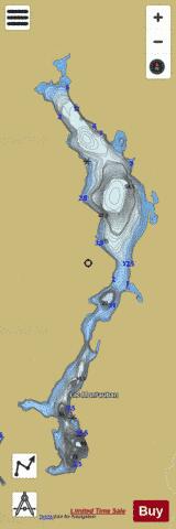
Montauban, Lac Fishing Map Stats | |
| Title | Montauban, Lac |
| Scale | 1:12000 |
| Districts | Mékinac, Portneuf |
| Nearby Cities | Saint-Marc-des-Carrières, Sainte-Thècle, Portneuf, Saint-Raymond, Saint-Basile-Sud, Saint-Tite, Gentilly, Donnacona, Pont-Rouge, Sainte-Croix |
| Area * | 977.61 acres |
| Shoreline * | 16.46 miles |
| Min Longitude | -72.19 |
| Min Latitude | 46.84 |
| Max Longitude | -72.16 |
| Max Latitude | 46.91 |
| Edition Label 1 | |
| Edition Label 2 | |
| Edition Label 3 | |
| Id | CA_QC_V_01036 |
| Country | CA |
| Projection | Mercator |
| * some Stats may include nearby/connecting waterbodies | |
| |||||||||||||||||||||||||||||||||||||||||||||||||||||||||||||||||||||||||||||||||||||||||||||||||||||||
|