Lovering, Lac fishing map is included in Quebec to Anticosti Island West nautical charts folio. It is available as part of iBoating : Canada Marine & Fishing App (now supported on multiple platforms including Android, iPhone/iPad, MacBook, and Windows(tablet and phone)/PC based chartplotter. ).
With our Lake Maps App, you get all the great marine chart app features like fishing spots, along with Lovering, Lac depth map. The fishing maps app include HD lake depth contours, along with advanced features found in Fish Finder / Gps Chart Plotter systems, turning your device into a Depth Finder. The Lovering, Lac Navigation App provides advanced features of a Marine Chartplotter including adjusting water level offset and custom depth shading. Fishing spots and depth contours layers are available in most Lake maps. Lake navigation features include advanced instrumentation to gather wind speed direction, water temperature, water depth, and accurate GPS with AIS receivers(using NMEA over TCP/UDP). Autopilot support can be enabled during ‘Goto WayPoint’ and ‘Route Assistance’.
Now i-Boating supports Fishing Points in Lovering, Lac.
Have more questions about the Nautical Chart App? Ask us.
Fishing Info for Lovering, Lac
Lake Lovering (French: Lac Lovering) is a lake located in the Memphrémagog Regional County Municipality of the Estrie region of Quebec, Canada. It is located south of the city of Magog. Lake Lovering is 6 kilometres (3.7 mi) long by 0.75 kilometres (0.47 mi) wide. It has a surface area of 4.6 square kilometres (1.8 sq mi) and an average depth of 25 metres (82 ft). It is situated at an elevation of 243 metres (797 ft). Lake Lovering is contaminated with polychlorinated biphenyl (PCB), dioxins and furans. These chemicals originated through a small stream retrieving water from a landfill. In 1970 concerned landowners created an organization, la Société de conservation du lac Lovering, in response to the consequences of rapid residential urbanization of the lake shore. Its goal is to raise awareness of the hazards to the lake to local residents and authorities.
More on Wikipedia...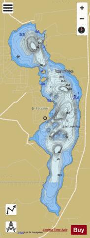
Lovering, Lac Fishing Map Stats | |
| Title | Lovering, Lac |
| Scale | 1:12000 |
| Districts | Memphrémagog |
| Nearby Cities | Magog, Stanstead, Sherbrooke, Valcourt, Coaticook, Bromptonville, Waterloo, Windsor, Richmond, Bromont |
| Area * | 1202.41 acres |
| Shoreline * | 11.28 miles |
| Min Longitude | -72.17 |
| Min Latitude | 45.14 |
| Max Longitude | -72.14 |
| Max Latitude | 45.19 |
| Edition Label 1 | |
| Edition Label 2 | |
| Edition Label 3 | |
| Id | CA_QC_V_01802 |
| Country | CA |
| Projection | Mercator |
| * some Stats may include nearby/connecting waterbodies | |
| |||||||||||||||||||||||||||||||||||||||||||||||||||||||||||||||||||||||||||||||||||||||||||||||||||||||
|