Upper Mazinaw Lake fishing map is included in Ontario Lakes nautical charts folio. It is available as part of iBoating : Canada Marine & Fishing App (now supported on multiple platforms including Android, iPhone/iPad, MacBook, and Windows(tablet and phone)/PC based chartplotter. ).
With our Lake Maps App, you get all the great marine chart app features like fishing spots, along with Upper Mazinaw Lake depth map. The fishing maps app include HD lake depth contours, along with advanced features found in Fish Finder / Gps Chart Plotter systems, turning your device into a Depth Finder. The Upper Mazinaw Lake Navigation App provides advanced features of a Marine Chartplotter including adjusting water level offset and custom depth shading. Fishing spots and depth contours layers are available in most Lake maps. Lake navigation features include advanced instrumentation to gather wind speed direction, water temperature, water depth, and accurate GPS with AIS receivers(using NMEA over TCP/UDP). Autopilot support can be enabled during ‘Goto WayPoint’ and ‘Route Assistance’.
Now i-Boating supports Fishing Points in Upper Mazinaw Lake.
Have more questions about the Nautical Chart App? Ask us.
Fishing Info for Upper Mazinaw Lake
Lake Mazinaw is a lake in the Addington Highlands north of Kaladar in Eastern Ontario. The lake is situated on the upper Mississippi River. It has a perimeter of 49 km (30 mi) and averages 41 m (135 ft) in depth with a maximum depth of 145 m (476 ft), making it the seventh-deepest lake in Ontario, including the Great Lakes. There is a narrows which divides the lake into two sections: South Mazinaw, and North Mazinaw, with North Mazinaw being larger and deeper. Bon Echo Provincial Park encompasses the central section of the lake, including the narrows between North and South Mazinaw and the Bon Echo Rock formation attracts rock climbers from all over the world. The lake's name comes from Mazinaabikinigan-zaaga'igan, meaning "painted-image lake" in Algonkian, referring to the pictographs on Bon Echo which overlooks the lake. Bon Echo rock, located on the eastern side of North Mazinaw, features over 260 native pictographs- often confused with petroglyphs – the largest visible collection in Canada - including the Ojibwa trickster figure and culture hero, Nanabush. The Rabbit man is the most famous pictograph visible today. The rock also contains a tribute to Walt Whitman, inscribed by Horace Traubel And Flora MacDonald Denison, who ran the Bon Echo Inn on the site of the provincial park during the 1910s. The inscription reads “my foothold is tenon’d and mortised in granite, I laugh at what you call dissolution and I know the amplitude of time.” A dam is located at the outflow of the lake to maintain the level of the lake and to control water flow into the Mississippi River during the spring runoff time. Peregrine Falcons have been reintroduced to the area- nesting on top of Bon Echo Rock. Mink can be spotted along the northern shores of the lake. Loons are native to the area and can be heard calling throughout the lake.
More on Wikipedia...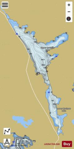
Upper Mazinaw Lake Fishing Map Stats | |
| Title | Upper Mazinaw Lake |
| Scale | 1:24000 |
| Districts | Frontenac, Lennox and Addington |
| Nearby Cities | Tweed, Madoc, Eganville, Marmora, Napanee, Deseronto, Stirling, Barry's Bay, Renfrew, Belleville |
| Area * | 3997.05 acres |
| Shoreline * | 34.00 miles |
| Min Longitude | -77.25 |
| Min Latitude | 44.85 |
| Max Longitude | -77.16 |
| Max Latitude | 44.97 |
| Edition Label 1 | |
| Edition Label 2 | |
| Edition Label 3 | |
| Id | CA_ON_V_103384082 |
| Country | CA |
| Projection | Mercator |
| * some Stats may include nearby/connecting waterbodies | |
|