Ahmic Lake fishing map is included in Ontario Lakes nautical charts folio. It is available as part of iBoating : Canada Marine & Fishing App (now supported on multiple platforms including Android, iPhone/iPad, MacBook, and Windows(tablet and phone)/PC based chartplotter. ).
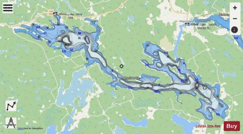
With our Lake Maps App, you get all the great marine chart app features like fishing spots, along with Ahmic Lake depth map. The fishing maps app include HD lake depth contours, along with advanced features found in Fish Finder / Gps Chart Plotter systems, turning your device into a Depth Finder. The Ahmic Lake Navigation App provides advanced features of a Marine Chartplotter including adjusting water level offset and custom depth shading. Fishing spots and depth contours layers are available in most Lake maps. Lake navigation features include advanced instrumentation to gather wind speed direction, water temperature, water depth, and accurate GPS with AIS receivers(using NMEA over TCP/UDP). Autopilot support can be enabled during ‘Goto WayPoint’ and ‘Route Assistance’.
Now i-Boating supports Fishing Points in Ahmic Lake.
Have more questions about the Nautical Chart App? Ask us.
Fishing Info for Ahmic Lake
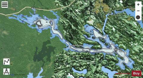
Ahmic Lake is a lake in Parry Sound District, Ontario, Canada, part of the Magnetawan River waterway in the Almaguin Highlands region. Ahmic Lake is approximately 19 km long and connects to two smaller lakes, Neighick (nicknamed Beaver Lake) and Crawford Lake. Wealthy American tourists have been visiting the area since the 1860s and bought large tracts of land around the lake. With most cottages staying in family hands, the lake's shores have been kept intact over the years, making Ahmic a lake with only moderate shoreline disturbance or alteration. Around the beginning of the 20th century, a number of fishing camps were built on Ahmic Lake, including Cedar Croft which stayed in business until the late 1950s. The lake is known for the presence of two swimming camps, , the boys camp, and , the girls camp. Chikopi was the world's first competitive swim camp. The two camps are directly across the lake from each other and to get from one to the other by water one paddles past Rocky Reef, which is a very exclusive tourist peninsula owned by a few American families. The tourist industry and the two swim camps are what kept the young people and adult residents in the small town of Ahmic Harbour employed for many decades and still contributes to the economic well-being of the area. Ahmic Harbour is located at the tip of the small bay of Ahmic Lake along Highway 124. Ahmic Lake was an ideal lake for the two swim camps due to the clear water and a size that allowed for training of marathon swimmers such as Marty Sinn.
More on Wikipedia...Popular fish species in this lake include Brown bullhead, Crappie, Esox, Lake whitefish, Largemouth bass, Northern pike, Pumpkinseed, Rainbow smelt, Rock bass, Smallmouth bass, Walleye and Yellow perch.
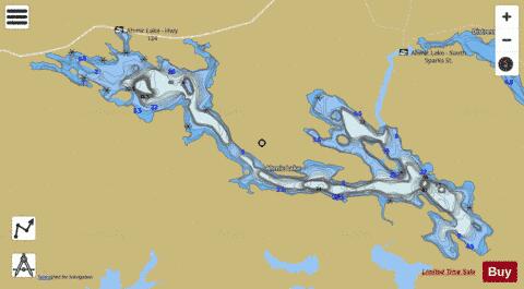
Ahmic Lake Fishing Map Stats | |
| Title | Ahmic Lake |
| Scale | 1:24000 |
| Districts | Parry Sound |
| Nearby Cities | Parry Sound, Huntsville, Powassan, Bracebridge, North Bay, Sturgeon Falls, Gravenhurst, Tay, Midland, Amigo Beach |
| Area * | 3952.24 acres |
| Shoreline * | 49.90 miles |
| Min Longitude | -79.78 |
| Min Latitude | 45.61 |
| Max Longitude | -79.61 |
| Max Latitude | 45.67 |
| Edition Label 1 | |
| Edition Label 2 | |
| Edition Label 3 | |
| Id | CA_ON_V_103381839 |
| Country | CA |
| Projection | Mercator |
| * some Stats may include nearby/connecting waterbodies | |
|