Lake Opeongo fishing map is included in Ontario Lakes nautical charts folio. It is available as part of iBoating : Canada Marine & Fishing App (now supported on multiple platforms including Android, iPhone/iPad, MacBook, and Windows(tablet and phone)/PC based chartplotter. ).
With our Lake Maps App, you get all the great marine chart app features like fishing spots, along with Lake Opeongo depth map. The fishing maps app include HD lake depth contours, along with advanced features found in Fish Finder / Gps Chart Plotter systems, turning your device into a Depth Finder. The Lake Opeongo Navigation App provides advanced features of a Marine Chartplotter including adjusting water level offset and custom depth shading. Fishing spots and depth contours layers are available in most Lake maps. Lake navigation features include advanced instrumentation to gather wind speed direction, water temperature, water depth, and accurate GPS with AIS receivers(using NMEA over TCP/UDP). Autopilot support can be enabled during ‘Goto WayPoint’ and ‘Route Assistance’.
Now i-Boating supports Fishing Points in Lake Opeongo.
Have more questions about the Nautical Chart App? Ask us.
Fishing Info for Lake Opeongo
Opeongo Lake is a lake in the Saint Lawrence River drainage basin in the geographic townships of Bower, Dickson, Preston and Sproule in the Unorganized South Part of Nipissing District in Northeastern Ontario, Canada. It is the largest lake in Algonquin Provincial Park and the source of the Opeongo River. The lake's name comes from the Algonquian word opeauwingauk meaning "sandy narrows". It has three arms, North, East and South, joined by narrows into a Y shape. The total area is 58 km2 (22.4 sq mi), the average depth 14.6 m (48 ft) and the maximum depth 49.4 m (162 ft). The primary outflow is the Opeongo River at the southeast tip of Annie Bay on the East Arm, controlled by the Opeongo Lake Dam, which flows via the Madawaska River to the Ottawa River. A store with camping supplies and dock, Algonquin access point 11 and the Harkness Laboratory of Fisheries Research are located on Sproule Bay at south end of South Arm and are all accessible from Ontario Highway 60. Consequently, the lake is a popular starting point for canoe trips into the interior of the park. Opeongo lake was to have been the endpoint of the Opeongo Line, one of a series of settlement roads built to open up this section of the province. It was the endpoint of the Whitney and Opeongo Railway, used for logging operations until the 1920s. Portions of this route now form part of Ontario Highway 60 and the access road connecting the lake to Highway 60.
More on Wikipedia...
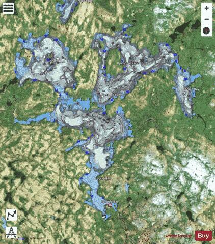
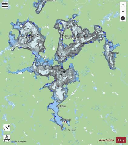
Lake Opeongo Fishing Map Stats | |
| Title | Lake Opeongo |
| Scale | 1:24000 |
| Districts | Nipissing |
| Nearby Cities | Haliburton Village, Mattawa, Barry's Bay, Huntsville, Chalk River, Deep River, Powassan |
| Area * | 14630.63 acres |
| Shoreline * | 119.85 miles |
| Min Longitude | -78.46 |
| Min Latitude | 45.62 |
| Max Longitude | -78.27 |
| Max Latitude | 45.76 |
| Edition Label 1 | |
| Edition Label 2 | |
| Edition Label 3 | |
| Id | CA_ON_CA_ON_V_103380463_on |
| Country | CA |
| Projection | Mercator |
| * some Stats may include nearby/connecting waterbodies | |
|