Lake Sparrow fishing map is included in Ontario Lakes nautical charts folio. It is available as part of iBoating : Canada Marine & Fishing App (now supported on multiple platforms including Android, iPhone/iPad, MacBook, and Windows(tablet and phone)/PC based chartplotter. ).
With our Lake Maps App, you get all the great marine chart app features like fishing spots, along with Lake Sparrow depth map. The fishing maps app include HD lake depth contours, along with advanced features found in Fish Finder / Gps Chart Plotter systems, turning your device into a Depth Finder. The Lake Sparrow Navigation App provides advanced features of a Marine Chartplotter including adjusting water level offset and custom depth shading. Fishing spots and depth contours layers are available in most Lake maps. Lake navigation features include advanced instrumentation to gather wind speed direction, water temperature, water depth, and accurate GPS with AIS receivers(using NMEA over TCP/UDP). Autopilot support can be enabled during ‘Goto WayPoint’ and ‘Route Assistance’.
Now i-Boating supports Fishing Points in Lake Sparrow.
Have more questions about the Nautical Chart App? Ask us.
Fishing Info for Lake Sparrow
Sparrow Lake is a lake in the Great Lakes Basin in Central Ontario, Canada. It is situated north-west of the town of Orillia and south of the town of Gravenhurst, Ontario and approximately 150 kilometres and a 1.5 hour drive north of the Greater Toronto Area. Sparrow Lake is the most southerly lake in the popular Muskoka tourist region. The lake was named after a William Sparrow, an Englishman, who fished and hunted the area in the 19th century. He disappeared one summer giving rise to stories that he may have been murdered. It is also slightly famous as being the northern setting for the Showcase TV show Paradise Falls. Various settings and lodges around the lake were used for filming. It is also home to Sparrow Lake Camp (https://sparrowlakecamp.com/) (founded 1912), the oldest children's recreational camp operated by the United Church of Canada. There is an abundance of resorts and lodges on the lake. There are also two golf courses, Lake St. George Golf Club and Evergreen Golf Center within 3 km.
More on Wikipedia...Popular fish species in this lake include Black crappie, Bowfin, Brown bullhead, Largemouth bass, Northern pike, Pumpkinseed, Rock bass, Smallmouth bass, Walleye and Yellow perch.
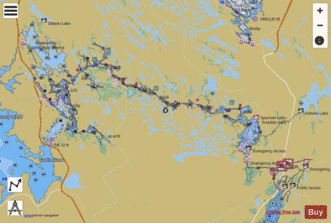
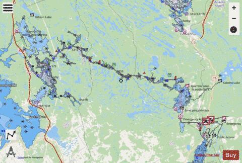
Lake Sparrow Fishing Map Stats | |
| Title | Lake Sparrow |
| This chart covers part of America’s Great Loop | |
| Scale | 1:24000 |
| Districts | Muskoka, Simcoe |
| Nearby Cities | Amigo Beach, Gravenhurst, Tay, Orillia, Midland, Marchmont - Bass Lake, Bracebridge, Elmvale, Oro Station - Hawkestone, Beaverton |
| Area * | 12959.37 acres |
| Shoreline * | 363.17 miles |
| Min Longitude | -79.77 |
| Min Latitude | 44.73 |
| Max Longitude | -79.29 |
| Max Latitude | 44.95 |
| Edition Label 1 | |
| Edition Label 2 | |
| Edition Label 3 | |
| Id | CA_ON_sparrow_mm_on |
| Country | CA |
| Projection | Mercator |
| * some Stats may include nearby/connecting waterbodies | |
|