Lizard Lake fishing map is included in Lakes and Rivers of British Columbia nautical charts folio. It is available as part of iBoating : Canada Marine & Fishing App (now supported on multiple platforms including Android, iPhone/iPad, MacBook, and Windows(tablet and phone)/PC based chartplotter. ).
With our Lake Maps App, you get all the great marine chart app features like fishing spots, along with Lizard Lake depth map. The fishing maps app include HD lake depth contours, along with advanced features found in Fish Finder / Gps Chart Plotter systems, turning your device into a Depth Finder. The Lizard Lake Navigation App provides advanced features of a Marine Chartplotter including adjusting water level offset and custom depth shading. Fishing spots and depth contours layers are available in most Lake maps. Lake navigation features include advanced instrumentation to gather wind speed direction, water temperature, water depth, and accurate GPS with AIS receivers(using NMEA over TCP/UDP). Autopilot support can be enabled during ‘Goto WayPoint’ and ‘Route Assistance’.
Now i-Boating supports Fishing Points in Lizard Lake.
Have more questions about the Nautical Chart App? Ask us.
Fishing Info for Lizard Lake
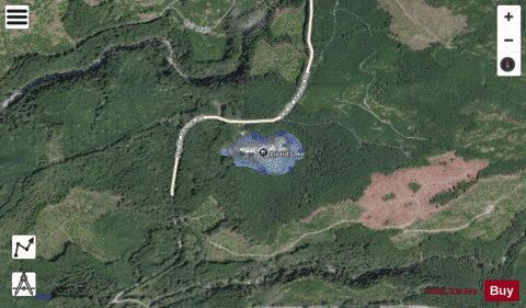
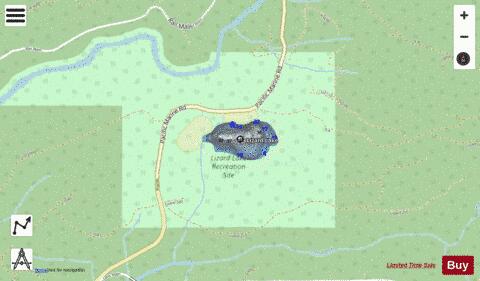
Lizard Lake is a lake on Vancouver Island, in British Columbia, Canada near the town of Port Renfrew. It is located in the Capital Regional District (not to be confused with Lizard Lake (Vancouver Island), a lake located to the north near the city of Port Alberni). The lake is northeast of the junction of Harris Creek and the San Juan River. Lizard Lake lies at an elevation of 65 metres (213 ft) above sea level and has a surface area of 8 hectares (20 acres). Its mean depth is 15 metres (49 ft) with a maximum of 16 metres (52 ft). Lizard Lake is located along the Pacific Marine Circle Route to the east of Fairy Lake, and is a popular recreation site for swimming, canoeing and camping. In 2015 a large fire near the lake led to the closure of the highway and burned more than 150 hectares (370 acres) of forest.
More on Wikipedia...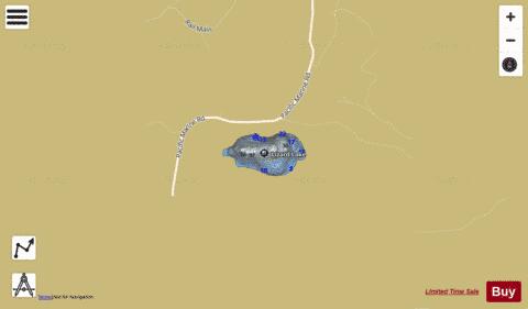
Lizard Lake Fishing Map Stats | |
| Title | Lizard Lake |
| Scale | 1:6000 |
| Districts | Capital |
| Nearby Cities | Lake Cowichan, Duncan, Sooke, Ladysmith, Chemainus, Shawnigan - Mill Bay, Cowichan Bay, Cedar, Nanaimo, Crofton |
| Area * | 21.49 acres |
| Shoreline * | 0.78 miles |
| Min Longitude | -124.23 |
| Min Latitude | 48.60 |
| Max Longitude | -124.22 |
| Max Latitude | 48.61 |
| Edition Label 1 | |
| Edition Label 2 | |
| Edition Label 3 | |
| Id | CA_BC_lizard_lake__bc |
| Country | CA |
| Projection | Mercator |
| * some Stats may include nearby/connecting waterbodies | |
| |||||||||||||||||||||||||||||||||||||||||||||||||||||||||||||||||||||||||||||||||||||||||||||||||||||||
|