Peitahigan Lake fishing map is included in Saskatchewan Fishing Maps nautical charts folio. It is available as part of iBoating : Canada Marine & Fishing App (now supported on multiple platforms including Android, iPhone/iPad, MacBook, and Windows(tablet and phone)/PC based chartplotter. ).
With our Lake Maps App, you get all the great marine chart app features like fishing spots, along with Peitahigan Lake depth map. The fishing maps app include HD lake depth contours, along with advanced features found in Fish Finder / Gps Chart Plotter systems, turning your device into a Depth Finder. The Peitahigan Lake Navigation App provides advanced features of a Marine Chartplotter including adjusting water level offset and custom depth shading. Fishing spots and depth contours layers are available in most Lake maps. Lake navigation features include advanced instrumentation to gather wind speed direction, water temperature, water depth, and accurate GPS with AIS receivers(using NMEA over TCP/UDP). Autopilot support can be enabled during ‘Goto WayPoint’ and ‘Route Assistance’.
Now i-Boating supports Fishing Points in Peitahigan Lake.
Have more questions about the Nautical Chart App? Ask us.
Fishing Info for Peitahigan Lake
Peitahigan Lake is a lake in Meadow Lake Provincial Park in the Canadian Province of Saskatchewan in the boreal forest ecozone of Canada. The lake is one of six notable lakes in the Rusty Creek watershed. The other lakes include Rusty, First Mustus, Second Mustus, Third Mustus, and Fourth Mustus. Rusty Creek and the lakes are part of the Waterhen River drainage basin. The Waterhen River is a tributary of the Beaver River, which flows north into Lac Île-à-la-Crosse and the Churchill River, a major tributary in the Hudson Bay drainage basin. Several streams feed into Peitahigan Lake, including ones that drain the southern slopes of the Mostoos Hills. The outflow is a short east-flowing creek that flows into Third Mustus Lake. Access to the lake is via a gravel road that runs along the west side of the lake that connects up with Highway 224 south of Peitahigan Lake. An 11-kilometre section of the Boreal Trail goes around the lake and over by the Mustus Lakes.
More on Wikipedia...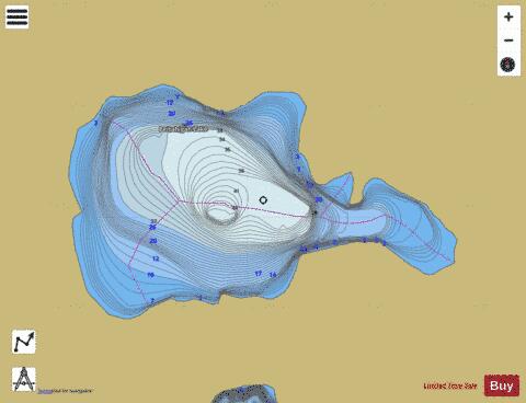
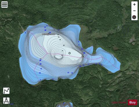
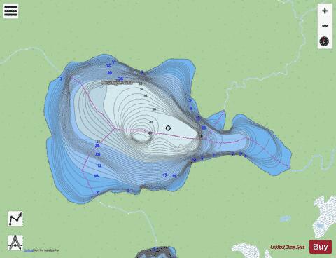
Peitahigan Lake Fishing Map Stats | |
| Title | Peitahigan Lake |
| Scale | 1:12000 |
| Nearby Cities | Meadow Lake |
| Area * | 677.82 acres |
| Shoreline * | 5.27 miles |
| Min Longitude | -108.96 |
| Min Latitude | 54.44 |
| Max Longitude | -108.92 |
| Max Latitude | 54.45 |
| Edition Label 1 | |
| Edition Label 2 | |
| Edition Label 3 | |
| Id | CA_SK_Peitahigan_Lake_sk |
| Country | CA |
| Projection | Mercator |
| * some Stats may include nearby/connecting waterbodies | |
|