Whitesand Lake fishing map is included in Ontario Lakes nautical charts folio. It is available as part of iBoating : Canada Marine & Fishing App (now supported on multiple platforms including Android, iPhone/iPad, MacBook, and Windows(tablet and phone)/PC based chartplotter. ).
With our Lake Maps App, you get all the great marine chart app features like fishing spots, along with Whitesand Lake depth map. The fishing maps app include HD lake depth contours, along with advanced features found in Fish Finder / Gps Chart Plotter systems, turning your device into a Depth Finder. The Whitesand Lake Navigation App provides advanced features of a Marine Chartplotter including adjusting water level offset and custom depth shading. Fishing spots and depth contours layers are available in most Lake maps. Lake navigation features include advanced instrumentation to gather wind speed direction, water temperature, water depth, and accurate GPS with AIS receivers(using NMEA over TCP/UDP). Autopilot support can be enabled during ‘Goto WayPoint’ and ‘Route Assistance’.
Now i-Boating supports Fishing Points in Whitesand Lake.
Have more questions about the Nautical Chart App? Ask us.
Fishing Info for Whitesand Lake
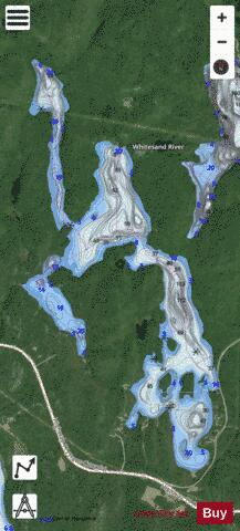
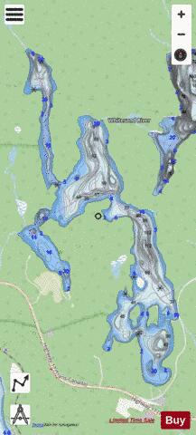
Whitesand Lake is a lake in Thunder Bay District, Ontario, Canada, part of the Hewitson River system. Whitesand Lake is just north of Highway 17, about 9 kilometres (6 mi) east of the community of Rossport and 8 kilometres (5 mi) west of the community of Schreiber. The lake is about 4 kilometres (2 mi) long at its longest, and 1.7 kilometres (1.1 mi) at its widest. It is shaped roughly like the letter "H", with an elongated and fatter lower right arm. The primary inflow is the Whitesand River at the north side of the lake, and the lake flows out at the south-west via the Hewitson River over the Rainbow Falls into Lake Superior.
More on Wikipedia...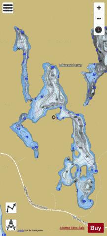
Whitesand Lake Fishing Map Stats | |
| Title | Whitesand Lake |
| Scale | 1:12000 |
| Districts | Thunder Bay |
| Nearby Cities | Geraldton |
| Area * | 675.99 acres |
| Shoreline * | 14.63 miles |
| Min Longitude | -87.40 |
| Min Latitude | 48.83 |
| Max Longitude | -87.37 |
| Max Latitude | 48.87 |
| Edition Label 1 | |
| Edition Label 2 | |
| Edition Label 3 | |
| Id | CA_ON_whitesand_lake_on |
| Country | CA |
| Projection | Mercator |
| * some Stats may include nearby/connecting waterbodies | |
|