Round Lake fishing map is included in Ontario Lakes nautical charts folio. It is available as part of iBoating : Canada Marine & Fishing App (now supported on multiple platforms including Android, iPhone/iPad, MacBook, and Windows(tablet and phone)/PC based chartplotter. ).
With our Lake Maps App, you get all the great marine chart app features like fishing spots, along with Round Lake depth map. The fishing maps app include HD lake depth contours, along with advanced features found in Fish Finder / Gps Chart Plotter systems, turning your device into a Depth Finder. The Round Lake Navigation App provides advanced features of a Marine Chartplotter including adjusting water level offset and custom depth shading. Fishing spots and depth contours layers are available in most Lake maps. Lake navigation features include advanced instrumentation to gather wind speed direction, water temperature, water depth, and accurate GPS with AIS receivers(using NMEA over TCP/UDP). Autopilot support can be enabled during ‘Goto WayPoint’ and ‘Route Assistance’.
Now i-Boating supports Fishing Points in Round Lake.
Have more questions about the Nautical Chart App? Ask us.
Fishing Info for Round Lake
Round Lake is a lake located in Killaloe, Hagarty and Richards Township, Renfrew County, Ontario, Canada. The Bonnechere River flows into the lake in the northwest and flows out of the lake at the southeast. There are two provincial parks on the lake, Bonnechere Provincial Park on the northwestern shore and Foy Provincial Park on the eastern shore. In the mid-1920s Hydro constructed a dam on the Bonnechere River downstream from the lake and upstream from the Tramore bridge at 45°37′13″N 77°27′36″W / 45.62028°N 77.46000°W (opposite side of the lake from Round Lake Resort) and flooded the land around the lake. The edge of the lake before the rise in water level was about 75 yards out from our present shore. Round Lake is the first major lake in the course of the Bonnechere River which begins at in Algonquin Park to the north, and passes through Golden Lake, Eganville, Douglas and Renfrew before emptying into the Ottawa River near Castleford. * v * t * e
More on Wikipedia...
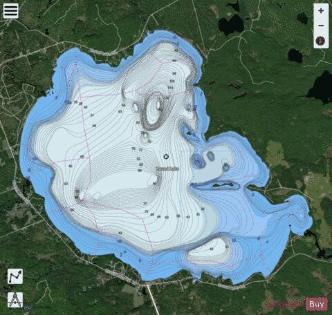
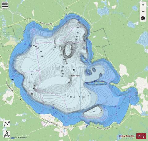
Round Lake Fishing Map Stats | |
| Title | Round Lake |
| Scale | 1:24000 |
| Districts | Renfrew |
| Nearby Cities | Barry's Bay, Petawawa, Chalk River, Eganville, Pembroke, Deep River, Fort-Coulonge, Renfrew, Shawville |
| Area * | 7357.90 acres |
| Shoreline * | 21.43 miles |
| Min Longitude | -77.57 |
| Min Latitude | 45.61 |
| Max Longitude | -77.48 |
| Max Latitude | 45.67 |
| Edition Label 1 | |
| Edition Label 2 | |
| Edition Label 3 | |
| Id | CA_ON_V_103381066 |
| Country | CA |
| Projection | Mercator |
| * some Stats may include nearby/connecting waterbodies | |
|