Kapuskasing Lake fishing map is included in Ontario Lakes nautical charts folio. It is available as part of iBoating : Canada Marine & Fishing App (now supported on multiple platforms including Android, iPhone/iPad, MacBook, and Windows(tablet and phone)/PC based chartplotter. ).
With our Lake Maps App, you get all the great marine chart app features like fishing spots, along with Kapuskasing Lake depth map. The fishing maps app include HD lake depth contours, along with advanced features found in Fish Finder / Gps Chart Plotter systems, turning your device into a Depth Finder. The Kapuskasing Lake Navigation App provides advanced features of a Marine Chartplotter including adjusting water level offset and custom depth shading. Fishing spots and depth contours layers are available in most Lake maps. Lake navigation features include advanced instrumentation to gather wind speed direction, water temperature, water depth, and accurate GPS with AIS receivers(using NMEA over TCP/UDP). Autopilot support can be enabled during ‘Goto WayPoint’ and ‘Route Assistance’.
Now i-Boating supports Fishing Points in Kapuskasing Lake.
Have more questions about the Nautical Chart App? Ask us.
Fishing Info for Kapuskasing Lake
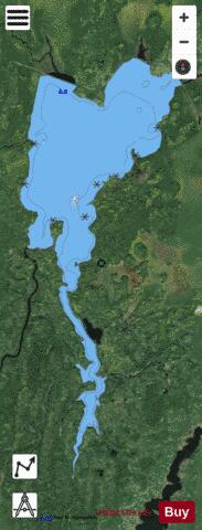
Kapuskasing Lake is a lake in Algoma District and Sudbury District in northeastern Ontario, Canada. It is in the James Bay drainage basin and is the source of the Kapuskasing River. The majority of the lake is in geographic Kapuskasing Township, Algoma District, with just the southern tip in geographic Sherlock Township, Sudbury District. The primary inflow at the southwest is the Chapleau River. The primary outflow is the Kapuskasing River at the northeast, of which the lake is the source. The Kapuskasing River flows via the Mattagami River and the Moose River to James Bay. The settlement of Elsas is at the northern end of the lake, and the railway point of Agate is just northwest of the lake. Both settlements are on the Canadian National Railway transcontinental railway main line, completed in 1915 as the Canadian Northern Railway, which follows the northern shore of the lake. The line is served by Via Rail transcontinental Canadian trains which stop at Elsas railway station.
More on Wikipedia...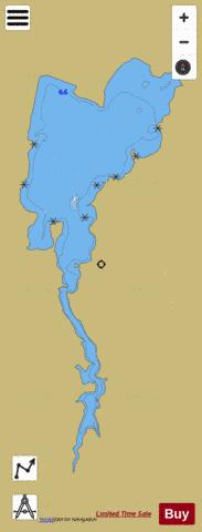
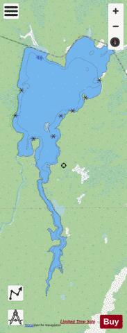
Kapuskasing Lake Fishing Map Stats | |
| Title | Kapuskasing Lake |
| Scale | 1:24000 |
| Districts | Algoma, Sudbury |
| Nearby Cities | Chapleau |
| Area * | 4530.47 acres |
| Shoreline * | 29.08 miles |
| Min Longitude | -82.96 |
| Min Latitude | 48.41 |
| Max Longitude | -82.90 |
| Max Latitude | 48.52 |
| Edition Label 1 | |
| Edition Label 2 | |
| Edition Label 3 | |
| Id | CA_ON_V_103380171 |
| Country | CA |
| Projection | Mercator |
| * some Stats may include nearby/connecting waterbodies | |
|