Nitinat Lake fishing map is included in Lakes and Rivers of British Columbia nautical charts folio. It is available as part of iBoating : Canada Marine & Fishing App (now supported on multiple platforms including Android, iPhone/iPad, MacBook, and Windows(tablet and phone)/PC based chartplotter. ).
With our Lake Maps App, you get all the great marine chart app features like fishing spots, along with Nitinat Lake depth map. The fishing maps app include HD lake depth contours, along with advanced features found in Fish Finder / Gps Chart Plotter systems, turning your device into a Depth Finder. The Nitinat Lake Navigation App provides advanced features of a Marine Chartplotter including adjusting water level offset and custom depth shading. Fishing spots and depth contours layers are available in most Lake maps. Lake navigation features include advanced instrumentation to gather wind speed direction, water temperature, water depth, and accurate GPS with AIS receivers(using NMEA over TCP/UDP). Autopilot support can be enabled during ‘Goto WayPoint’ and ‘Route Assistance’.
Now i-Boating supports Fishing Points in Nitinat Lake.
Have more questions about the Nautical Chart App? Ask us.
Fishing Info for Nitinat Lake
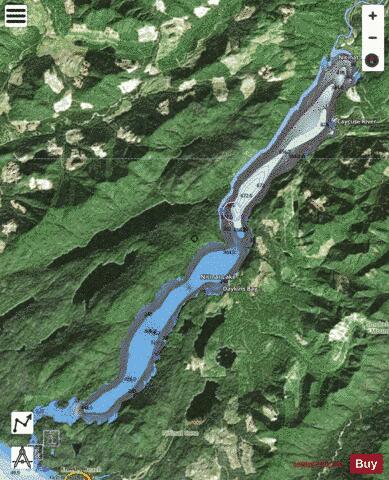
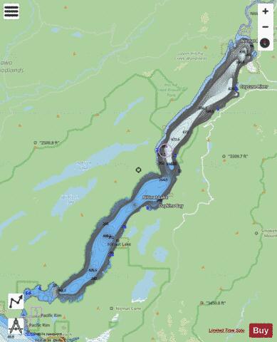
Nitinat Lake is a large lake and inlet on the southwestern coast of Vancouver Island, British Columbia, Canada. The lake is about 150 km (93 mi) northwest by road from Victoria, BC's capital on the southern tip of Vancouver Island, and about 60 km (37 mi) southwest by road from the town of Lake Cowichan. The city of Port Alberni is about 80 km (50 mi) by road to the north. The southern end of the lake lies in Pacific Rim National Park Reserve, which also contains Nitinat Hill on the lake's northern shore and Nitinat Cone on the southern shore. Hitchie Creek Provincial Park and Nitinat Lake Ecological Reserve lie on opposite sides of the lakeshore about a third of the way from the lake's northern shore and the point where Nitinat River flows into the lake. On the lake's eastern shore lie Mt. Rosander and the foot of Carmanah Mountain, the eastern part of which is in Carmanah Walbran Provincial Park. Nitinat Lake drains into the Pacific Ocean just north of the Pacific entrance to the Strait of Juan de Fuca via the Nitinat Narrows, a narrow tidal passage about 3 km (1.9 mi) long. Tidal bores (ocean waves travelling up the lake) occur on the narrows, the heights of which depend on tide heights, and these can be dangerous. The small First Nations village of Whyac lies on the southern lakeshore beside Nitinat Narrows and just north of the First Nations village of Clo-oose, also on the coast. The main volume of Nitinat Lake is salt water, with a thin layer of less dense fresh water floating on top.
More on Wikipedia...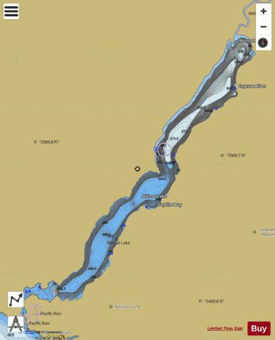
Nitinat Lake Fishing Map Stats | |
| Title | Nitinat Lake |
| Scale | 1:24000 |
| Districts | Alberni-Clayoquot, Cowichan Valley |
| Nearby Cities | Port Alberni, Parksville, Lake Cowichan, Fairwinds, Ucluelet, Nanaimo, Cedar, Courtenay, Cumberland, Ladysmith |
| Area * | 6694.01 acres |
| Shoreline * | 35.14 miles |
| Min Longitude | -124.86 |
| Min Latitude | 48.68 |
| Max Longitude | -124.67 |
| Max Latitude | 48.82 |
| Edition Label 1 | |
| Edition Label 2 | |
| Edition Label 3 | |
| Id | CA_BC_nitinat_lake__bc |
| Country | CA |
| Projection | Mercator |
| * some Stats may include nearby/connecting waterbodies | |
| |||||||||||||||||||||||||||||||||||||||||||||||||||||||||||||||||||||||||||||||||||||||||||||||||||||||
|