Lake Illawarra fishing map is included in New South Wales Fishing Maps nautical charts folio. It is available as part of iBoating : Australia Marine & Fishing App (now supported on multiple platforms including Android, iPhone/iPad, MacBook, and Windows(tablet and phone)/PC based chartplotter. ).
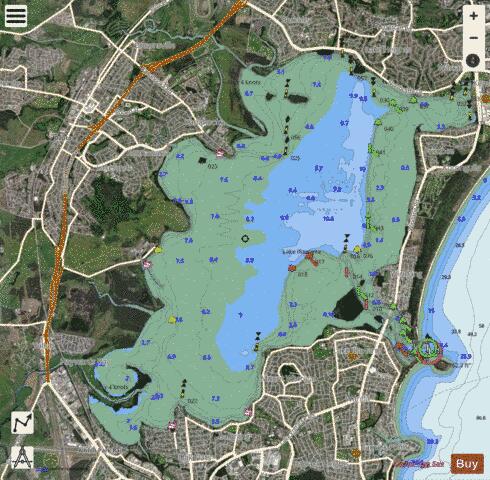
With our Lake Maps App, you get all the great marine chart app features like fishing spots, along with Lake Illawarra depth map. The fishing maps app include HD lake depth contours, along with advanced features found in Fish Finder / Gps Chart Plotter systems, turning your device into a Depth Finder. The Lake Illawarra Navigation App provides advanced features of a Marine Chartplotter including adjusting water level offset and custom depth shading. Fishing spots and depth contours layers are available in most Lake maps. Lake navigation features include advanced instrumentation to gather wind speed direction, water temperature, water depth, and accurate GPS with AIS receivers(using NMEA over TCP/UDP). Autopilot support can be enabled during ‘Goto WayPoint’ and ‘Route Assistance’.
Have more questions about the Nautical Chart App? Ask us.
Fishing Info for Lake Illawarra
Lake Illawarra (Aboriginal Tharawal language: various adaptions of Elouera, Eloura, or Allowrie; Illa, Wurra, or Warra meaning pleasant place near the sea, or, high place near the sea, or, white clay mountain), an open and trained intermediate wave dominated barrier estuary or large coastal lagoon, is located in the Illawarra region of New South Wales, situated about 100 kilometres (62 mi) south of Sydney, Australia. Until 2014, the lake environment was administered by the Lake Illawarra Authority (LIA), a New South Wales statutory authority established pursuant to the Lake Illawarra Authority Act 1987 (NSW) with the aim of transforming the degraded waters and foreshores of Lake Illawarra into an attractive recreational and tourist resource. In 2014, the LIA was replaced by the Lake Illawarra Estuary Management Committee (LIEMC), including representatives from Wollongong and Shellharbour City Councils, as well as independent scientific advisors, community members, and local Aboriginal representatives.
More on Wikipedia...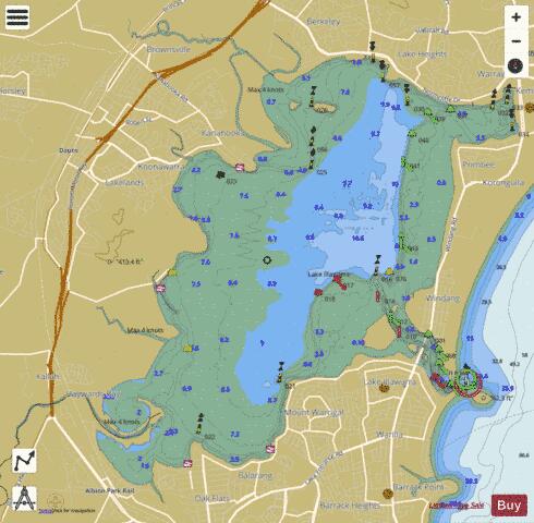
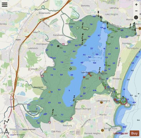
Lake Illawarra Fishing Map Stats | |
| Title | Lake Illawarra |
| Scale | 1:24000 |
| Area * | 8842.89 acres |
| Shoreline * | 56.70 miles |
| Min Longitude | 150.78 |
| Min Latitude | -34.56 |
| Max Longitude | 150.89 |
| Max Latitude | -34.48 |
| Edition Label 1 | |
| Edition Label 2 | |
| Edition Label 3 | |
| Id | AU_NSW_94_Lake_Illawarra |
| Country | Australia |
| Projection | Mercator |
| * some Stats may include nearby/connecting waterbodies | |
| ||||||||||||||||||||||||||||||||||||||||||||||||||||||||||||||||||||||||||||||||||||||||||||||||||||||||
|